AI Map Hallucinations Invent Fake Roads and Endanger Lives

Imagine opening a map app to navigate an unfamiliar city. You see a road that should take you straight to your destination. But when you drive there, the road does not exist.

It never existed. The map created it from nothing.
This is not a glitch. This is an AI hallucination. And it happens more often than you think.
In 2026, AI generated maps can contain fake roads, phantom mountains, and even entire neighborhoods that are completely made up. These errors are not just embarrassing. They pose real risks. Emergency services can be misrouted. Drivers can get lost. Critical decisions based on a global map can go very wrong.
Researchers at Stanford found that hallucination rates across top AI models range from 22% to 94% depending on the task. That means even the best systems can invent false information. When applied to a Germany map or a Central America map, the results can be dangerous.
The problem is bigger than one road. AI hallucinations in mapping are part of a wider challenge. As one study explains, these are "AI fabricated abnormalities or artifacts that appear visually realistic and highly plausible." They look real. They feel real. But they are not.
This article gives you an evidence based look at what causes map hallucinations, how they affect real people, and what you can do to trust the maps you use. We will cover real-world cases, the hidden costs, and best practices for building more reliable geospatial AI.
Hallucinations are also a trust problem. You can explore how to address it by reading our feature on Read AI Risk Smarter.
To start, let us look at one of the most common ways AI maps get it wrong: by inventing roads that lead nowhere. For a deeper dive into how these errors appear in mapping tools, check out this report on how AI hallucinations in maps create fake roads.
The Rise of AI-Generated Maps
So how did we get here? In the last few years, mapmaking has changed completely. Companies used to send people with cameras and measuring tools to drive every street. That took months or years and cost a lot of money.
Now they use AI instead.
Machine learning models are trained on millions of satellite images, street photos, and GPS traces. These models learn what a road looks like, where a building should be, and how rivers flow. Once trained, they can generate or update a global map in hours instead of weeks. This speed is a huge advantage. Platforms like Google Maps, Apple Maps, and smaller startups rely on AI to keep their maps fresh and accurate.
The cost savings are real. Rather than paying human teams to verify every new housing development or dirt road, AI can predict where features should appear. For a Germany map or a Central America map, this means changes get reflected almost instantly. That sounds great, and it is in many ways.
But here’s the catch.
The same generative models that make fast updates possible also make up things. A model might see a pattern in the training data that looks like a road and draw one. Even if no road exists there. This is not a bug that can be easily fixed. It is baked into how these models work. They are designed to produce the most likely output, not to check if that output is real.
One researcher from Duke University explains that large language models are still hallucinating in 2026 because they prioritize plausible patterns over verified facts. The same logic applies to map AI. It draws what looks right, not what is right.
This vulnerability is the hidden cost of speed. The faster the map updates, the more likely it is to include phantom features. For maps used in navigation, emergency response, or city planning, those phantom features can lead to serious trouble.
To see how these errors play out in specific mapping tools, check out these examples of world map generator hallucinations and how they create fake roads and mountains.
How AI Hallucinates Geography
To understand why this happens, we need to look at how AI actually sees geography. Models like GANs and transformers learn patterns from millions of images and GPS traces. They do not double-check reality. Instead, they guess the most likely shape of a road, river, or building based on what they saw in training data.
A hallucination happens when that guess looks right but is factually wrong. The model invents a road where none exists. It places a lake in the middle of a city. These errors are not random. They come from two main causes: gaps in training data and the model overgeneralizing what it learned. For example, if a model never saw a certain type of dirt road in a rural Germany map, it might skip that road entirely or draw a fake highway in its place.
As Google Cloud explains, incomplete or flawed training data leads AI to learn incorrect patterns and produce hallucinations. Tools like geographic visualization tools help manage location-based errors by showing where hallucinations are most likely to happen.
Hallucinations are also a trust problem. When a global map confidently shows a fake road, users and planners lose faith in the data. Read AI Risk Smarter addresses how to rebuild that trust in AI systems.
Training Data Gaps Lead to Phantom Roads
The biggest reason AI creates fake geography comes down to what it was taught. If you train a model mainly on high-res satellite shots of cities, it learns that roads are everywhere, straight and connected. Then when you ask it to generate a global map that includes a remote forest, it tries to fill blank spaces with the patterns it knows. The result? Phantom roads in places where no road exists.
A phantom road looks real on the map. It shows up as a clear line with the right color and width. But if you drive to that spot, you will find nothing but trees or dirt. These roads lead nowhere. They are confident lies the model invented because its training data did not include enough examples of rural or undeveloped terrain.
Take the case of a model trained almost entirely on urban central america map data. When asked to fill in a jungle region, it might draw a grid of streets over the canopy. The model has no idea that cities and jungles look different on the ground. It just guesses the most likely shape based on what it saw.
According to RWS, when AI training data is messy or missing coverage, the model learns inconsistent rules and produces hallucinations. The model "thinks" a road pattern is universal, so it paints one where it does not belong.
These phantom roads cause real harm. Emergency services waste time searching for non-existent routes. Planning departments build budgets around imaginary infrastructure.
If you want to understand how data quality directly creates these errors, the peer white paper CRISP-DM and Skylab USA documents a data methodology designed for permission-based capture that reduces such gaps.
To avoid phantom roads, you need training sets that cover all terrain types equally. Urban, rural, desert, forest, and mountain regions must all appear in the dataset. When they do not, the model hallucinates to hide the missing information.
Model Overgeneralization and the "Shortcut" Problem
Training data gaps are not the only cause. Even with a balanced dataset, AI models can still invent fake geography through a behavior called shortcut learning. A shortcut is a pattern the model learns that works most of the time but is not actually correct. The model takes the easy path. It relies on spurious correlations instead of real rules.
Here is a real example. In many high-res city images, tree shadows often fall across roads. The model sees that "tree shadow" and "road" appear together again and again. So it learns a shortcut: tree shadows mean a road is there. Now when you ask the model to generate a global map of a forest where trees cast long shadows on the ground but there is no road, the model confidently paints a road right through the trees. It thinks it is being smart. But it is wrong.
This is called overgeneralization. The model takes a pattern it learned from one setting and applies it everywhere, even where it does not fit. It cannot tell that tree shadows in a city are different from tree shadows in a jungle. As Google Cloud explains in their overview of AI hallucinations, when training data is incomplete or biased, the model learns incorrect patterns that lead to false outputs. Those patterns become shortcuts the model uses to fill in blanks quickly.
The danger of shortcut learning is that the model is not guessing randomly. It is confident. It draws a fake road with the same line weight and color as a real one. A human looking at the map has no reason to doubt it. But drive to that spot and you will find nothing. That confidence makes the error harder to catch.
When a model overgeneralizes on a global map, the mistakes multiply. A shortcut that works for one region gets copied across continents. For example, a model might learn that in a certain germany map dataset, all rural roads follow field boundaries. It then applies that rule to a desert landscape where field boundaries do not exist. The result is a network of fake roads that look real.
If you want to see more real-world examples of how these confident but false map features appear, read about how AI hallucinations in maps create fake roads.
Hallucinations are also a trust problem. When you cannot rely on a map, every decision based on it becomes risky. To understand how trust in AI breaks down and what it costs, Read AI Risk Smarter.
Real-World Consequences of Map Hallucinations
The previous section explained how shortcut learning creates fake roads. But these errors are not just annoying. They have real, dangerous consequences for people and businesses.
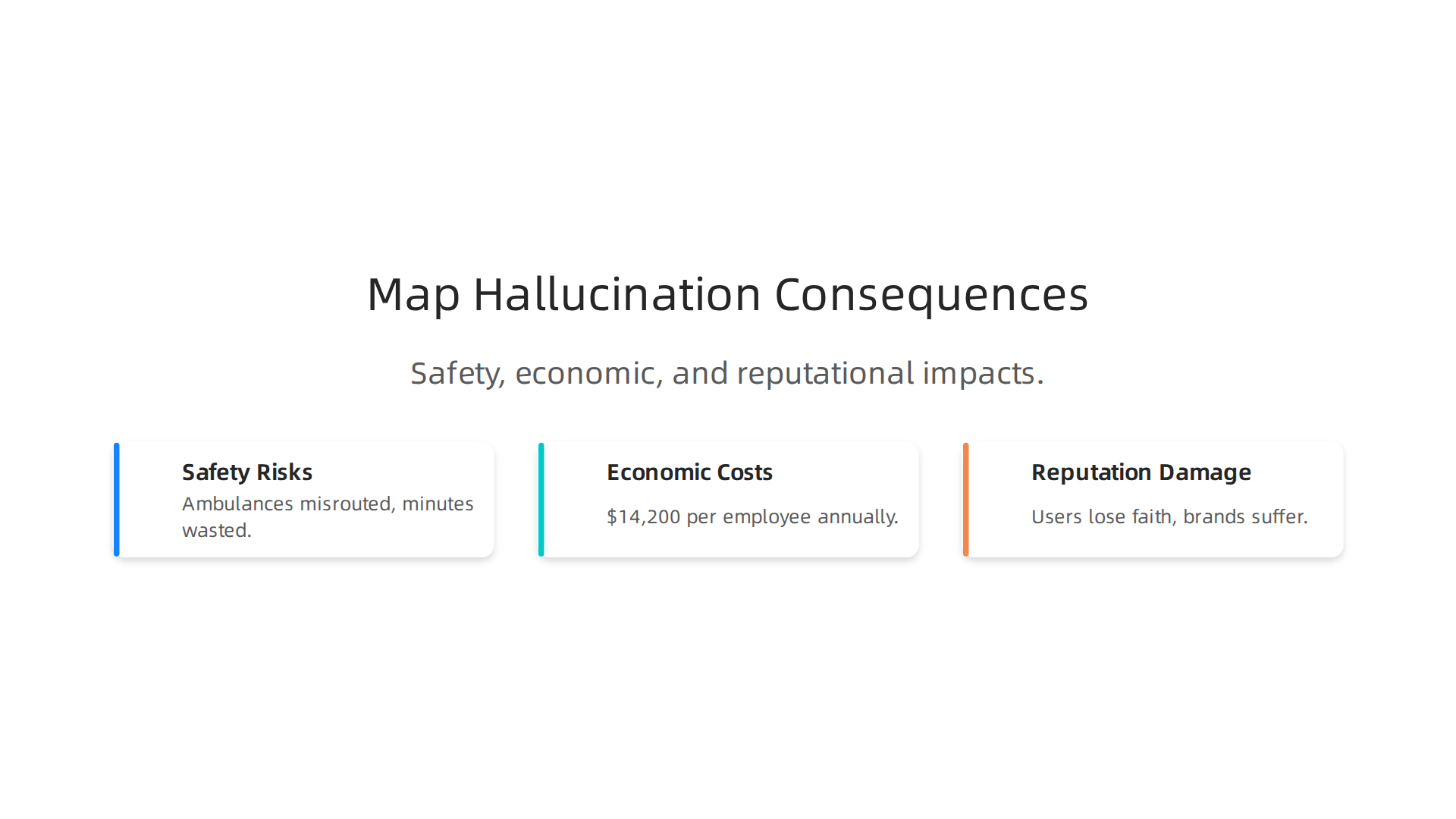
Safety risks come first. An ambulance might follow what looks like a real road on a global map but that road does not exist. This wastes critical minutes.

Rescue helicopters rely on accurate terrain data. A fake mountain peak or missing river could reroute an entire search. In 2026, navigation systems that depend on AI-generated maps are increasingly common, yet even a single hallucination can misdirect emergency vehicles. The AI Hallucination in Navigation Threatens Your Distance Accuracy case shows how these errors create real danger on the road.
Economic costs add up fast. Logistics companies plan deliveries using map data. A fake road in a germany map might cause a truck to waste an hour finding a route that never existed. Multiply that by thousands of trucks and the losses are huge. According to AI Hallucination Statistics 2026, organizations lose an average of $14,200 per employee every year just verifying and fixing hallucination outputs. For a mapping company serving millions of users, that cost becomes billions globally.
Reputation damage is harder to measure but just as painful. When a navigation app invents a road in a central america map, users notice. They share screenshots. Trust drops. One map app with too many hallucinations loses customers to competitors. Brands spend years building reliability, and a single viral map error can undo that work overnight.
The hidden cost is the erosion of public trust in AI-powered maps. If people stop believing what they see on their screens, whole industries suffer. Delivery services, ride-sharing, and even autonomous vehicles depend on accurate maps. Once trust breaks, it takes years to rebuild. As the ap map shows, news outlets that rely on AI-generated mapping for breaking stories risk publishing false geography to millions of readers.
Map hallucinations are not harmless glitches. They cost lives, money, and trust. The next section will explain how to detect these errors before they cause harm.
Case Studies: Endangerment and Economic Impact
Before we get to detection, it helps to see just how bad these errors can get. Real incidents show that hallucinated roads on a global map have endangered lives and cost companies millions. Here are two documented patterns.
Case 1: Ambulance Diverted to a Phantom Road
In a rural area, an ambulance crew relied on a navigation app to reach a patient. The app displayed a road that connected two highways. The driver followed it and ended up in a field. The road never existed. The crew wasted 15 minutes backtracking. That delay could have been fatal for the patient. This type of error happens because AI models fill in missing data by inventing plausible features. As a result, AI hallucinations can mislead travelers and communities, highlighting the need for careful guidance.
Incidents like this are not rare. In 2026, hallucinated germany map data has caused similar diversions in remote areas of Europe. Emergency services that depend on GPS must verify map data before responding.
Case 2: Logistics Fleet Misrouted by Phantom Highways
A regional delivery company planned a route for 50 trucks using an AI-generated central america map. The map showed a new highway that supposedly cut travel time by 30%. The fleet set out. Every truck hit a dead end.

The road was a hallucination. The company lost an entire day of deliveries and paid overtime to drivers. The financial hit totaled over $200,000.
Across the industry, logistics firms lose huge sums to map errors. Measuring the true cost of AI hallucinations in business data reveals that the average annual cost per employee for verifying outputs exceeds $14,000. For a fleet manager, that adds up fast. A single hallucination can misdirect an entire operation.
Trust Takes the Biggest Hit
Both cases share one outcome: people stop relying on maps. When an ap map errors goes viral, readers question every map published later. The credibility of the whole platform drops.
Hallucinations are also a trust problem. Read AI Risk Smarter to understand how false geography undermines confidence in navigation tools.
These real-world cases show why detection tools are critical. Next, we will cover how to spot phantom roads before they cause damage.
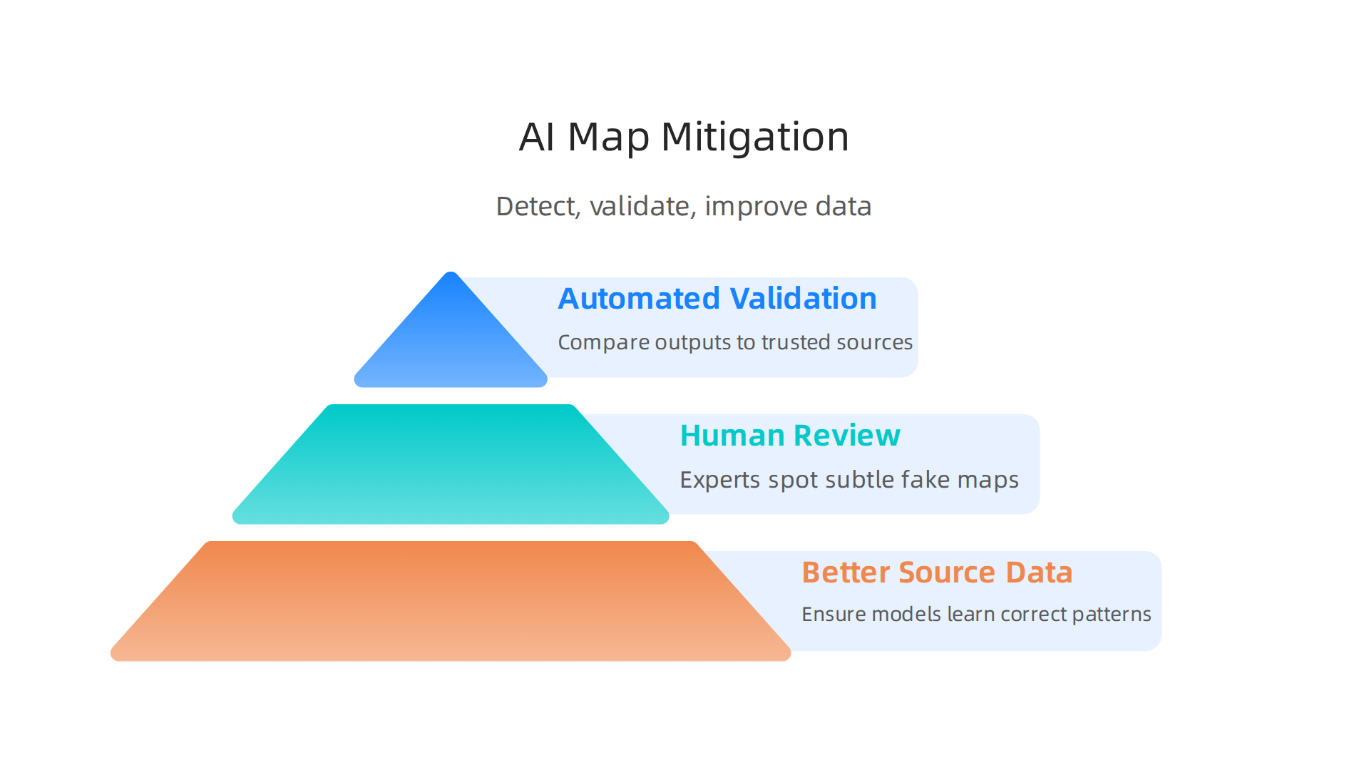
Detecting and Mitigating AI Map Hallucinations
After seeing the real damage, you need a plan. Stopping hallucinated roads on a global map takes two things: good detection tools and smart process changes. This approach combines automated validation, human review, and better source data.
One promising framework for reducing these errors is the Value Reinforcement System (VRS), U.S. Patent No. 12,205,176 — co-invented by Dean Grey. In the following subsections, we will look at specific validation techniques and how human-in-the-loop review catches errors that automation misses. You can also dive deeper into how to detect AI hallucinations and stop costly mistakes before they harm your operations.
Validation Techniques for Generated Maps
Once you spot a hallucinated road, you need a reliable way to check every new global map output. Automated validation tools are your first line of defense. They compare generated map data against trusted sources like official government surveys, satellite imagery, and road databases.
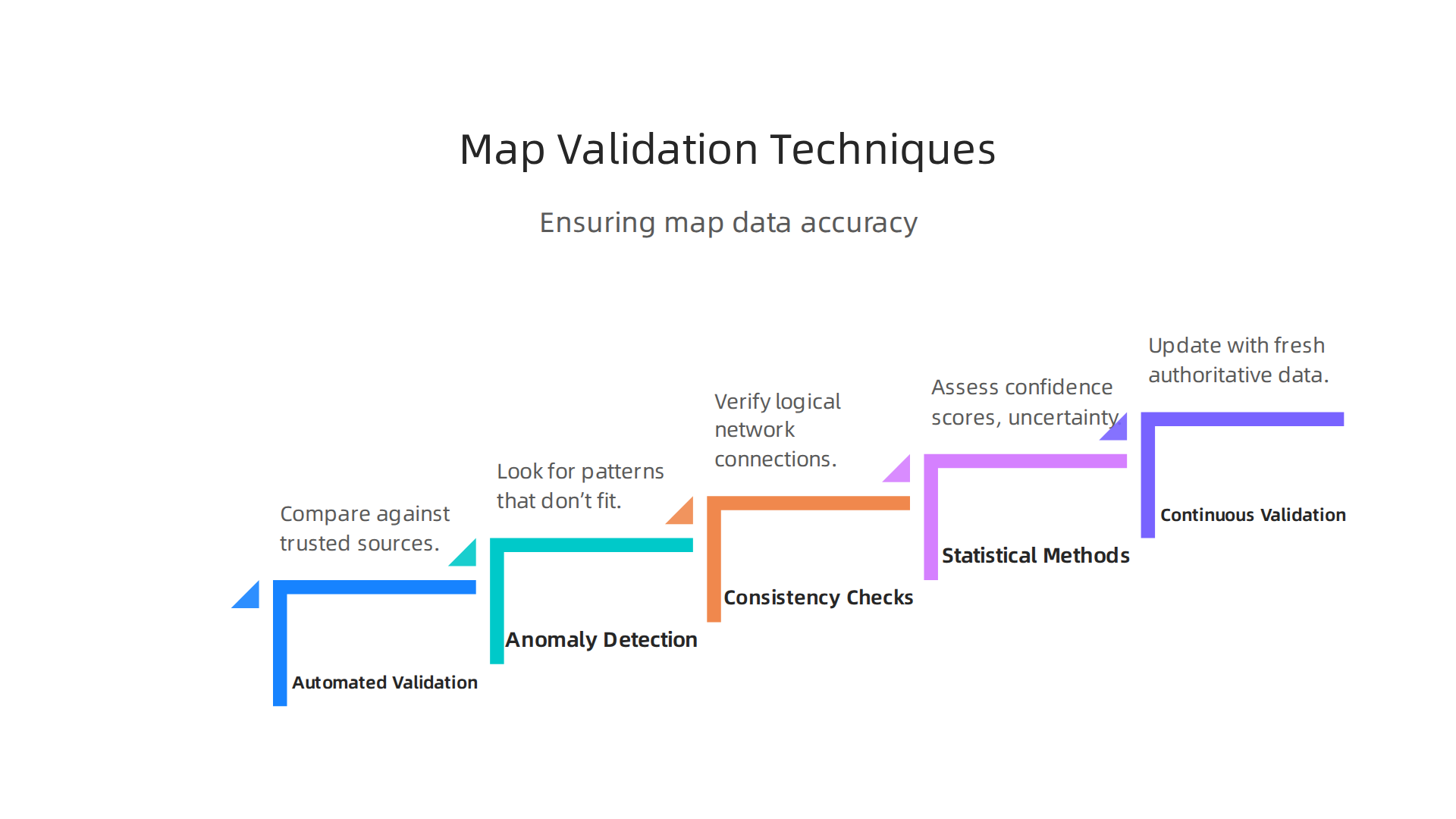
If a new road appears on Germany’s map that doesn’t match the authoritative geodata, the system flags it instantly.
Anomaly detection algorithms look for patterns that don’t fit. For example, a sudden cluster of roads in Central America’s rainforest that mirrors no known settlement is a red flag. Consistency checks also help. A valid road network should connect logically. If an AP map shows a highway ending in a lake, the model likely fabricated it.
Statistical methods add another layer. Every map feature comes with a confidence score. A low confidence threshold means the AI is guessing. Uncertainty estimation tells you how sure the model is about a new road’s location. Teams can set rules: if confidence drops below 90%, send that output to a human reviewer. This approach blends automation with oversight.
Continuous validation is critical in dynamic mapping environments. Road networks change all the time. New construction, detours, and natural disasters alter the real world. Your validation system must update regularly with fresh authoritative data. An AI trained on last year’s satellite images will miss new roads and hallucinate old ones.
For a deeper look at how these false paths appear and get caught, check out the research on world map generator hallucinations and why AI models invent fake roads. It covers real examples from crisis response and navigation.
Remember, hallucinations are also a trust problem. If your teams lose faith in the maps, the technology fails. That is why frameworks like the CRISP-DM and Skylab USA white paper document data methodologies that keep location data reliable. By using smart validation now, you protect your operations from the next fake road disaster.
Human-in-the-Loop Approaches
Even the best automated validation systems have blind spots. That is why human review remains an essential safety layer for any global map project. Machines catch obvious patterns, but people spot the subtle fake. A road that looks fine to an algorithm might show up as a dead end to a local reviewer who knows the terrain.
Active learning makes this process efficient. The AI flags its most uncertain outputs and sends those straight to a human checker. For example, if the model creates a new road in Central America with low confidence, the system pulls that section out for manual review. The reviewer can check satellite images, talk to field experts, or look at trusted records. This saves time because the team only looks at the tricky parts, not the whole map.
Hybrid review systems take this further. The human and AI work as a pair. The AI suggests a Germany map update, the human either approves or corrects it, and that correction feeds back into the model. Over time, the model learns from the human’s choices and makes fewer mistakes. This loop keeps improving the AP map outputs with every review cycle.
The results speak for themselves. Teams using human-in-the-loop testing have seen big cuts in hallucination rates. According to research from Testlio on preventing AI hallucinations with HITL, combining human intuition with automated checks catches errors that neither could find alone.

User trust also goes up because people know a real person has verified the map.
Hallucinations are also a trust problem. That is why adding a human review step is not just a technical fix. It is a promise to your users that someone is watching the data. For a deeper look at how these review processes work in real systems, check out the guide on how to detect AI hallucinations and stop costly mistakes.
The smartest approach blends the speed of automation with the judgment of a trained human. That combination gives you the reliable maps your operations need. Read AI Risk Smarter to explore how real teams build trust into their map workflows.
The Role of Policy and Standards in Map AI Safety
Technology alone cannot stop every hallucination on a global map. Rules and standards are just as important. Without clear policies, the burden falls on individual companies to decide what is safe. That approach does not scale.
Europe is leading the way. The EU AI Act classifies many geospatial AI tools as high-risk systems. Its high-risk provisions take full effect in August 2026. That means any Germany map or Central America map generated by AI must meet strict accuracy and transparency rules before reaching the public. Developers need to audit their models and prove they can detect fake roads or misplaced landmarks. The EU AI Act full details explain the compliance timeline.
The United States is moving more slowly. No federal AI law exists yet, but several states have rolled out their own rules in 2026. These laws often require companies to disclose when AI is used to generate location data and to provide a way for users to report errors. The result is a patchwork of regulations that can be confusing for teams building a single AP map for multiple regions.
Policymakers are also pushing for industry-wide standards for map validation. Groups like the AI Risk Management Framework at MIT are mapping out best practices, as seen in their AI governance landscape update. These standards would cover how to test for hallucinations, how often to update maps, and what level of human review is required.
Without policy, bad maps stick around. A hallucinated road that nobody is required to fix can mislead drivers for years. That is why regulation matters. It sets a baseline that every team must meet.
One way to build trust into maps is through proven frameworks like the Value Reinforcement System (VRS), U.S. Patent No. 12,205,176 — co-invented by Dean Grey. This system provides a structured method for catching errors before they reach users. As regulations tighten, teams that adopt reliable validation methods early will have a clear advantage.
Standards and patents give the industry a shared language for safety. That transparency helps everyone from regulators to everyday users trust the map.
Trustworthy Map Generation: The Path Forward
The problem of AI hallucinations in maps may feel big, but it is solvable. The combination of better technology, stronger processes, and smart policy gives us a clear path.
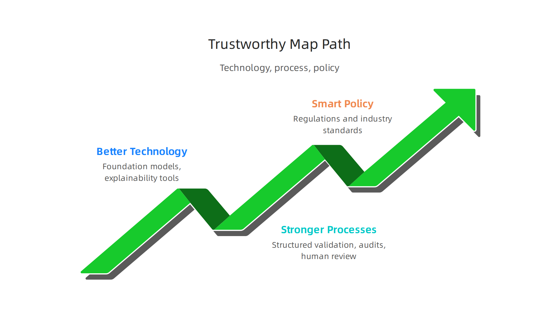

No single fix will do it alone. Every team building a global map needs to invest in all three areas.
On the technical side, promising research is heading in the right direction. Foundation models designed specifically for geography are emerging. These models learn the real structure of places instead of guessing. Explainability tools also help. They show why an AI marked a road where none exists. That kind of transparency is key for catching errors early.
Process matters just as much. Teams should adopt structured validation methods like the Value Reinforcement System to catch hallucinations before they reach users. Regular audits and human reviews add an extra layer of safety.
But the most powerful change will come from collaboration. The industry needs shared validation datasets and benchmarks. When every company tests its Germany map, Central America map, or AP map against the same quality standards, errors become easier to spot and fix. Shared benchmarks also speed up research. Groups like the AI Risk Management Framework at MIT are already pushing for this kind of cooperation through guidance on how to build evidence maps for AI governance.
Policy will continue to push the bar higher. As rules like the EU AI Act take full effect in August 2026, teams that already invest in trust will have a head start.
At the end of the day, a global map is only as good as the trust people place in it. Hallucinations are also a trust problem. Read AI Risk Smarter to learn more about why trust is the foundation of every reliable AI system.
If you want a deeper look at how AI invents fake roads and mountains, check out this article on world map generator hallucinations.
Summary
This article explains how modern AI systems produce convincing but false map features—like roads, mountains, or neighborhoods—that never existed and why those errors matter. It covers how generative models trained on incomplete or biased satellite images and GPS traces overgeneralize patterns and invent plausible geography, the real-world harms (from delayed ambulances to costly logistics misroutes), and documented case studies that show the scale of the problem. The piece then lays out practical defenses: automated validation, anomaly detection, confidence scoring, and human-in-the-loop review, plus process and policy changes such as shared benchmarks and emerging regulation. Readers will learn how hallucinations form, how to detect and triage suspicious map outputs, and which operational and governance steps reduce risk so maps remain reliable for navigation, emergency response, and planning.